Showing posts with label Jane Rosoux. Show all posts

Tuesday, 7 June 2011

Wealdway- Buxted to Berwick

Jane Rosoux reports...

I attach photographs taken on my walk along the Wealdway from Buxted to Berwick Station on Saturday, 4th June.

There were 10 in the party at the start (plus a dog)...


and we were fortunate to have good weather for the walk - and dry conditions underfoot - because it ended up as 22.3 miles instead of the intended 20 miles as a result of a combination of navigational errors and footpath diversions.

We were somewhat behind schedule by the time we stopped for lunch at the 'Kings Head', East Hoathly at around 1.50 pm, where one member of the party dropped out, speeded up to some extent between there and Horesbridge Mill (on the northern edge of Hailsham), where a further three participants dropped out, and really pushed up the pace thereafter to arrive at Berwick Station at 7.05 pm.

Despite the distance it was an enjoyable day over gently undulating terrain with attractive villages, good views and mostly good paths.


Monday, 12 July 2010

Wealdway 1: Gravesend to Borough Green

"There were 8 of us on Saturday's ramble along the Wealdway from Gravesend to Borough Green. Although the weather was hot it was bearable.

"We started by having a look at the statue of Princess Pocahuntas near the ferry terminal and the start of the Wealdway.


"However, instead of following the official route out of Gravesend along the busy A227 we took a quieter but slighly longer route via a B-road to join the Wealdway near Field Court.

"From there we were in very pleasant countryside following a well-waymarked trail, which was easy going.


"After 11 miles or so and around 3 hours 45 minutes we diverted to Harvel for lunch, where some picnicked whilst others enjoyed pub food at the 'Amazon and Tiger'. Soon after lunch we crossed the Pilgrim's Way then had a brief stop at Coldrum Long Barrow, from where we had good views of the North Downs away to the east. When we reached Wrotham Heath we decided to follow the Wealdway a little further to the south before heading west to Borough Green Station, which we reached at 5.45 pm after covering 19 miles in around 6 hours 30 minutes (excluding an hour for the lunch stop)."


Thanks to Jane for leading the walk, and sending me the walk report and the photos.

.

Sunday, 25 April 2010

Haddenham to Aylesbury

Jane Rosoux writes...

"I attach a selection of the photographs I took on my ramble from Haddenham & Thame Parkway to Aylesbury.


It was a lovely day on Saturday, albeit somewhat hazy, and six of us spent an enjoyable 16 miles walking through picture-postcard villages, such as Long Crendon, and attractive farmland in the Vale of Aylesbury.


The oil-seed rape was in full flower,


the National Trust Courthouse at Long Crendon opened as we were passing,


the hawthorn bushes were covered in blossom,


orchids, dandelions and lesser celandines were amongst other wild flowers in bloom.

And whilst we waited at Aylesbury for our train back to London we were able to enjoy very good value tea, coffee and cakes courtesy of Morrisons!"

Many thanks to Jane for leading the walking, reporting and photographing it!

.

Friday, 9 April 2010

Lewes Circular

Jane Rosoux reports on Clare Kirkbride's 20 mile circular walk around Lewes...

"There were 11 in the party at the start, 9 of whom did the full distance.


[Clare Kirkbride 2nd left]

We were very lucky with the weather, which was dry with some sun but quite breezy. Clare had chosen an attractive route with plenty of excellent views and also selected a good spot for our picnic lunch where some gorse bushes were so effective as a wind break that it felt positively warm.


[A rare picture of Jane Rosoux, 2nd left]


Although it was muddy in places we made such good speed that some of the party managed to catch the 4.50 pm train back. The rest of us enjoyed a brief tour of some of the attractions of Lewes, including the horse pond and the castle,...


...which dates from 1066. Towards the end of the walk we passed the Pioneer V8 car shown below...


...a local man returning from exercising his Barbary falcon...


... and a bare-chested canoist on the river Ouse..."


As usual the reports are greatly appreciated.

.

Thursday, 18 March 2010

Tring Circular around the Ashridge Estate.

Jane Rosoux writes.....

"I attach the photographs I took on Saturday's Hampstead Ramblers' walk from Tring mainly along the Ashridge Estate Boundary Trail.

Although the weather was cloudier and chillier than forecast it was quite pleasant - dry with some sunny spells. A party of 10 started out from Tring Station around 10.10 am...


...and, upon reaching the Ashridge Visitor Centre near the Bridgewater Monument, we set off anticlockwise along the Boundary Trail, which had been established in 1995 to celebrate the National Trust's Centenary.

The waymarking was generous....


The going underfoot was good and the route took us through attractive woodland, farmland and chalk downland with good views...


...The day concluded when 7 of us continued up to Gallows Hill and Ivinghoe Beacon


where the views were enhanced by the late afternoon sun and as we followed The Ridgeway Path back to Tring Station we had glimpses of a fine sunset through the trees...


We just made the 5.56 train back to London with 2 minutes to spare! All present were very pleased with the 18 mile Boundary Trail and would be happy to do it again, perhaps in late autumn when the leaves are turning."

Thank You Jane.

.

Tuesday, 5 January 2010

Tracing the River Fleet from Temple to Hampstead

Jane Rosoux writes..."A party of more than 40 set out from Temple Station on Sunday at 10.40 a.m. and enjoyed bright but cold conditions.


"The point under Blackfriars road bridge at which the Fleet flows into the Thames was pointed out and, shortly afterwards, the Golden Boy of Pye Corner...


.
"We soon passed Barts Hospital...


...."then Smithfield Market, and then followed an interesting route to St Pancras Old Church via small streets and alleys (passing the lady shown below high up on a wall)...


"...and through St Pancras Station where we visited the well-appointed (free) toilets. The image below was taken at St Pancras Old Church.


"We then walked up St Pancras Way to the 'Constitution' pub beside Regent's Canal


"By the time we arrived at the Talacre Square Community Sports Centre / 'Prince of Wales' pub at 12.45 pm, which were over half way, we were ready for lunch and those of us who brought our food found convenient tables and chairs at first floor level. Unfortunately, a few who ordered food from the snack bar were still waiting to be served by the time the rest of us were ready to leave at around 1.35 pm but the party still numbered over 30.

"We passed through estates of fine houses and other buildings on the way to the lowest of the existing Hampstead ponds. We then followed the Hampstead brook to its source
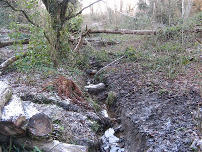


"before climbing up to the Vale of Health, Cannon Place and Well Passage to arrive at the site of the medicinal well which was developed into Hampstead Spa
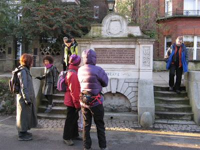


"After reaching Hampstead Station, having covered around 7.5 miles, a few of us walked another 2 miles to Golders Green Station via Hampstead Parish Church where the artist John Constable and John Harrison of longitude fame are buried..."


Many Thanks as usual Jane. It should be noted that Jane had only come back from our New Year trip the day before leading this one!

.
Wednesday, 9 September 2009

Rochford Circular

Ten Ramblers joined Walk Leader Jane Rosoux on the South coast near Southend last Sunday.

As we moved out to the coast the countryside ...

gave way to a more bleak, windswept landscape...

Our walk was planned to be 15 miles long,

though some navigational difficulties led to us walking 17!

History, both ancient and modern, surrounded us. We walked through the site of the court of King Canute, Canewdon.


The village lock-up would have been used to detain miscreants overnight until they could be transported to the county jail.

This pill box was part of the coastal defences from the second World War.

The low-lying, flood-prone estuary land even led some of the local farmers to build structures on stilts....


Finally, we were all puzzled as to what the crop was in this picture. Any suggestions or ideas? Just click on "comments" below right and share your thoughts.


.

Friday, 10 July 2009

Gerald Colton Way 4, Radlett to Rickmansworth

Jane Rosoux writes...

"I attach photographs which I took on today's walk along Section 4 of the Gerald Colton Way from Radlett to Rickmansworth. A party of seven set out from Radlett Station at around 10.15 am, including two members of the North West London Group and one from the South Bank Group.

Once we had left the built-up area we were delighted to walk past fields of white-flowered flax plants.


The fields of ripening oats and hay meadows which we subsequently passed through seemed very dull in comparison, probably because the farmers had been all too efficient at eradicating the wild flowers which would have added splashes of colour.


Our route took us past Letchmore Heath, Stanmore Common and across Bentley Priory Open Space and we finally arrived at our lunch stop at 'The Case is Altered' public house, Harrow Weald Common after 2 1/2 hours. There we were blessed with excellent views from the adjoining car park, including Harrow Hill in the near distance.


After lunch we went through Grim's Dyke Open Space


and crossed Grim's Dyke Golf Course before arriving at the bridge over the railway line near Hatch End Station where two more left the party (the first had dropped out near the entrance to Bentley Priory).

Two further members dropped out near Pinner Hill Golf Course leaving two of us to complete the least interesting part of the walk, through Oxhey Woods, past Hampermill Lake, then a long stretch along the Ebury Way, eventually passing lakes formed from gravel-digging and crossing the Grand Union Canal at Batchworth Lock


before entering Rickmansworth and arriving at the station at 5.00 pm just in time to catch a fast train back to London. We covered just over 16 miles in around 5 hours 40 minutes, excluding the lunch stop, at an average speed, including other stops, of 2.82 mph."

.

Friday, 12 June 2009

The Seawalls of Canvey Island, Sunday 7th June.

Torrential overnight rain and thunderstorms at dawn led my wife and I to roll over and go back to sleep last Sunday, while Jane Rosoux enjoyed Caryn Mackenzie's walk on the Essex Coast.

Shamefaced, I give you her walk report...

"Only four of us travelled to Benfleet for the Sea Walls of Canvey Island walk, perhaps because there was quite a lot of overnight rain and the weather forecast for the rest of the day was not good. However the proverb "rain before seven, fine before eleven" as usual turned out to be true and we had a fine day with quite a lot of sunshine, although in the morning we found ourselves wading through long, wet grass on the dykes at the western end of the island and I for one regretted not wearing waterproof trousers or gaiters.

However, by the time we reached 'The Lobster Smack' where we stopped for lunch we had dried out in the sun.


Shortly after lunch we reached the beach at Thorney Bay


and soon afterwards we passed the graffiti shown below...


On reaching the sailing centre we decided to divert from the route and walk to Canvey Point and were rewarded by the experience of traversing the salt marsh


and having a good view of Leigh Marsh and Leigh-on-Sea on the far side of Benfleet Creek


It was agreed that the section of the walk from Canvey Point back to Benfleet Station, with a continuous stretch of salt marsh on our right and Hadleigh Marsh and Castle in the distance was the most scenic part of the walk and that the walk would be well worth repeating on another occasion.

For the record the distance was 15.5 miles, including the detour to Canvey Point and we walked for 5.5 hours - an average speed of around 2.8 mph."

.